

Click to read general information about afghans


Buy a pattern
for this afghan
on the order form


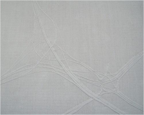
SPAGHETTI JUNCTION MAP
Spaghetti Junction map in cable knitting.
Designed and knitted by Ben Ashforth.
The Gravelly Hill interchange, junction 6 of the M6 motorway, was constructed between 1968 and 1972 and immediately acquired the nickname “spaghetti junction” because of the complicated, looping appearance of its 4 km of slip roads. The roads are supported on a total of 559 columns, with several rivers, canals and railways underneath.

Scroll down for more information about
Spaghetti Junction Map
Sorry!
There is no pattern
for this afghan


KNITTING INFORMATION
Knitted in double knitting yarn.

CONSTRUCTION INFORMATION
Knitted with a reverse stocking-

Click arrows for more pictures
This cable knit map of Spaghetti Junction is a successor to Cable Tube Map. Unlike Cable Tube Map, it has gradual sweeping curves and in a few places, the cables run parallel to the rows of knitting, which I didn’t think was possible when I made Cable Tube Map.
Each column of cable knitting represents one lane of traffic, giving this depiction of the junction a scale of approximately 1000:1.